The Urban Toolkit: A Grammar-based Framework for Urban Visual Analytics

Source: ArXiv

AI Quick Summary

The Urban Toolkit (UTK) is a flexible visualization framework designed to simplify the authoring of web-based urban data visualizations through a high-level grammar tailored for common urban use cases. It introduces the concept of knots to merge different urban data layers, facilitating easier integration and analysis for urban experts and reducing the complexity for programmers.

Share: Share on X LinkedIn

Summary

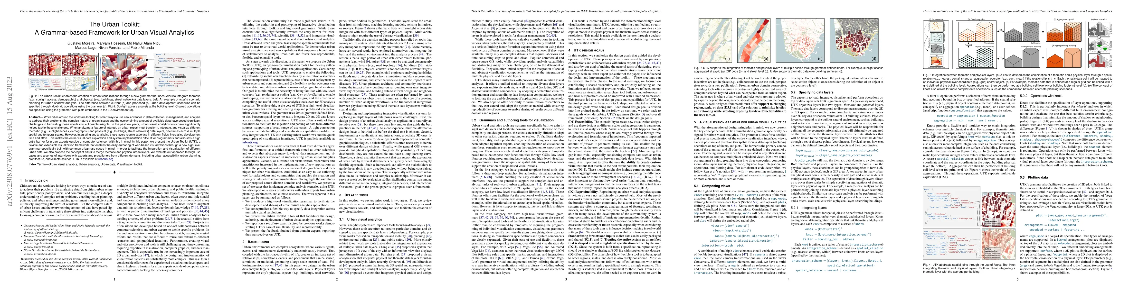
While cities around the world are looking for smart ways to use new advances in data collection, management, and analysis to address their problems, the complex nature of urban issues and the overwhelming amount of available data have posed significant challenges in translating these efforts into actionable insights. In the past few years, urban visual analytics tools have significantly helped tackle these challenges. When analyzing a feature of interest, an urban expert must transform, integrate, and visualize different thematic (e.g., sunlight access, demographic) and physical (e.g., buildings, street networks) data layers, oftentimes across multiple spatial and temporal scales. However, integrating and analyzing these layers require expertise in different fields, increasing development time and effort. This makes the entire visual data exploration and system implementation difficult for programmers and also sets a high entry barrier for urban experts outside of computer science. With this in mind, in this paper, we present the Urban Toolkit (UTK), a flexible and extensible visualization framework that enables the easy authoring of web-based visualizations through a new high-level grammar specifically built with common urban use cases in mind. In order to facilitate the integration and visualization of different urban data, we also propose the concept of knots to merge thematic and physical urban layers. We evaluate our approach through use cases and a series of interviews with experts and practitioners from different domains, including urban accessibility, urban planning, architecture, and climate science. UTK is available at urbantk.org.

AI Key Findings

Generated Sep 03, 2025

Methodology

The Urban Toolkit (UTK) is a grammar-based framework for urban visual analytics, designed to simplify the integration and visualization of diverse urban data layers across multiple scales. It introduces a high-level visualization grammar tailored for urban use cases, along with the concept of 'knots' for merging thematic and physical urban layers.

Key Results

  • UTK enables easy authoring of web-based visualizations through a flexible and extensible framework.
  • Knots facilitate the integration and visualization of different urban data layers, including thematic (e.g., sunlight access, demographics) and physical (e.g., buildings, street networks) layers.
  • The framework supports multi-scale exploration, allowing users to analyze data at neighborhood, lot, and building scales.
  • UTK abstracts low-level steps in urban data analytics, such as downloading, parsing OSM data, data joining, rendering, and navigation.
  • The tool has been evaluated through use cases and interviews with experts from urban accessibility, urban planning, architecture, and climate science.

Significance

UTK is significant as it lowers the barrier for urban experts to engage in visual data exploration and system implementation, making it easier for them to translate urban data into actionable insights.

Technical Contribution

The Urban Toolkit (UTK) presents a novel, grammar-based declarative framework for urban visual analytics, simplifying common urban data tasks and facilitating the prototyping of complex analysis scenarios.

Novelty

UTK distinguishes itself by offering a concise, easy-to-learn and modify specification for a wide range of visual analytical tasks, along with customizable links between layers that summarize various geospatial operators into single functionalities. It also ensures reproducibility and shareability through human-readable JSON files, enhancing collaboration and transparency.

Limitations

  • The current implementation may struggle with high-resolution geometric data, leading to computationally expensive matching operations between physical and thematic layers.
  • UTK's support for temporal data is limited, with no scalable method to handle time series data structures.

Future Work

  • Investigate the integration of more efficient algorithms and data structures to enable higher-resolution physical models and thematic data.
  • Extend the grammar to better handle temporal data and incorporate time series data structures.
  • Incorporate other simulation capabilities, such as wind and noise, to support urban scenario planning.
  • Conduct a controlled user study to evaluate ease-of-use and investigate deployment on various platforms, including immersive environments.

Paper Details

PDF Preview

Download PDF

Key Terms

urban (0.376)
experts (0.187)
layers (0.183)
analyzing (0.164)
science (0.159)
visual (0.151)
challenges (0.134)
street (0.132)

Citation Network

Current paper (gray), citations (green), references (blue)

Display is limited for performance on very large graphs.

Current Paper
Citations
References
Click to view
Title Authors Year Actions

Comments (0)

This website uses cookies to ensure you get the best experience. Learn more