The research employs a transformer-based model trained on multi-source satellite data, including Sentinel-2 and GEDI lidar, to estimate canopy height globally. The model uses a hierarchical architecture with temporal and spatial attention mechanisms, and incorporates a custom growth loss function to improve accuracy over time.
Publication
Metrics
Quick Answers
What methodology did the authors use?
The research employs a transformer-based model trained on multi-source satellite data, including Sentinel-2 and GEDI lidar, to estimate canopy height globally. The model uses a hierarchical architecture with temporal and spatial attention mechanisms, and incorporates a custom growth loss function to improve accuracy over time. More in Methodology →
What are the key results?
Achieved high accuracy with MAE of 0.51m and R² of 0.77 for global canopy height estimation — Demonstrated better performance in predicting taller trees compared to existing methods More in Key Results →
Why is this work significant?
This research provides a scalable, cost-effective solution for global forest monitoring, enabling better carbon stock estimation and deforestation detection through accurate canopy height mapping. More in Significance →
What are the main limitations?
Performance may degrade in areas with limited satellite coverage or dense cloud cover — Unable to distinguish between small trees, shrubs, and ground elevation due to GEDI label constraints More in Limitations →
Abstract
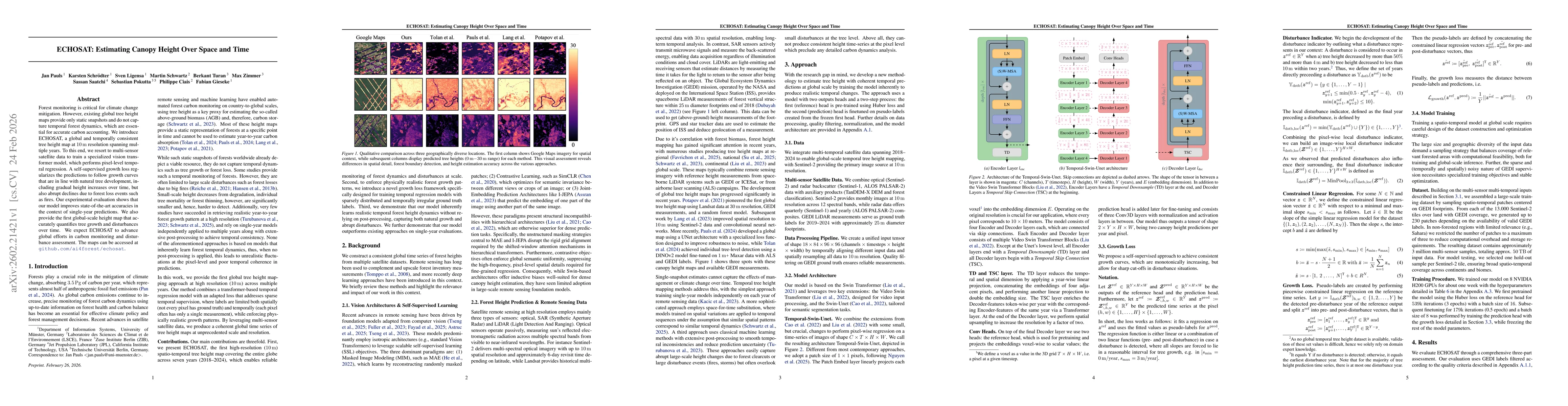
Forest monitoring is critical for climate change mitigation. However, existing global tree height maps provide only static snapshots and do not capture temporal forest dynamics, which are essential for accurate carbon accounting. We introduce ECHOSAT, a global and temporally consistent tree height map at 10 m resolution spanning multiple years. To this end, we resort to multi-sensor satellite data to train a specialized vision transformer model, which performs pixel-level temporal regression. A self-supervised growth loss regularizes the predictions to follow growth curves that are in line with natural tree development, including gradual height increases over time, but also abrupt declines due to forest loss events such as fires. Our experimental evaluation shows that our model improves state-of-the-art accuracies in the context of single-year predictions. We also provide the first global-scale height map that accurately quantifies tree growth and disturbances over time. We expect ECHOSAT to advance global efforts in carbon monitoring and disturbance assessment. The maps can be accessed at https://github.com/ai4forest/echosat.
Key Findings, in focus
Seven facets of this paper, analysed and brought into focus by AI.
This research provides a scalable, cost-effective solution for global forest monitoring, enabling better carbon stock estimation and deforestation detection through accurate canopy height mapping.
- Achieved high accuracy with MAE of 0.51m and R² of 0.77 for global canopy height estimation
- Demonstrated better performance in predicting taller trees compared to existing methods
- Showed lower error rates in tropical rainforest regions like the Amazon and Congo Basin
This research provides a scalable, cost-effective solution for global forest monitoring, enabling better carbon stock estimation and deforestation detection through accurate canopy height mapping.
Developed a novel growth loss function that enhances temporal consistency in canopy height predictions and introduced a hybrid temporal-spatial attention mechanism for multi-source data fusion.
The work introduces a custom growth loss function and a hierarchical transformer architecture specifically designed for temporal-spatial analysis of canopy height, distinguishing it from previous methods that lack such specialized training objectives.
- Performance may degrade in areas with limited satellite coverage or dense cloud cover
- Unable to distinguish between small trees, shrubs, and ground elevation due to GEDI label constraints
- Integrate with higher-resolution satellite data for improved local-scale analysis
- Explore temporal dynamics for detecting forest recovery and degradation patterns
- Validate against more diverse LiDAR datasets for global benchmarking
Discussion 0