ArxivLens

Publication

Published: May 12, 2025
Updated: May 13, 2025
Categories: cs.CV, cs.LG

Metrics

Source: ArXiv

AI Quick Summary

Researchers introduce TUM2TWIN, a large-scale multimodal urban digital twin benchmark dataset to address challenges in creating comprehensive UDTs, featuring 32 data subsets over 100,000 $m^2$ of georeferenced 3D models and various observations.

Quick Answers

What is "TUM2TWIN: Introducing the Large-Scale Multimodal Urban Digital Twin Benchmark Dataset" about?

Researchers introduce TUM2TWIN, a large-scale multimodal urban digital twin benchmark dataset to address challenges in creating comprehensive UDTs, featuring 32 data subsets over 100,000 $m^2$ of georeferenced 3D models and various observations.

What methodology did the authors use?

The paper introduces TUM2TWIN, a comprehensive multimodal Urban Digital Twin benchmark dataset, encompassing georeferenced, semantically aligned 3D models, networks, and diverse observations spanning terrestrial, mobile, aerial, and satellite data across 100,000 $m^2$ with 767 GB of data. More in Methodology →

What are the key results?

TUM2TWIN dataset supports robust analysis of sensors and development of advanced reconstruction methods. — Demonstrates potential of TUM2TWIN in downstream tasks including novel view synthesis (NeRF and Gaussian Splatting), solar potential analysis, point cloud semantic segmentation, and LoD3 building reconstruction. More in Key Results →

Why is this work significant?

This research lays a foundation for overcoming current limitations in UDT creation, fostering new research directions and practical solutions for smarter, data-driven urban environments. More in Significance →

What are the main limitations?

The dataset currently covers a limited geographical area (100,000 $m^2$). — Specific details on dataset acquisition and processing methodologies are not extensively detailed. More in Limitations →

Paper Preview

Abstract

Urban Digital Twins (UDTs) have become essential for managing cities and integrating complex, heterogeneous data from diverse sources. Creating UDTs involves challenges at multiple process stages, including acquiring accurate 3D source data, reconstructing high-fidelity 3D models, maintaining models' updates, and ensuring seamless interoperability to downstream tasks. Current datasets are usually limited to one part of the processing chain, hampering comprehensive UDTs validation. To address these challenges, we introduce the 
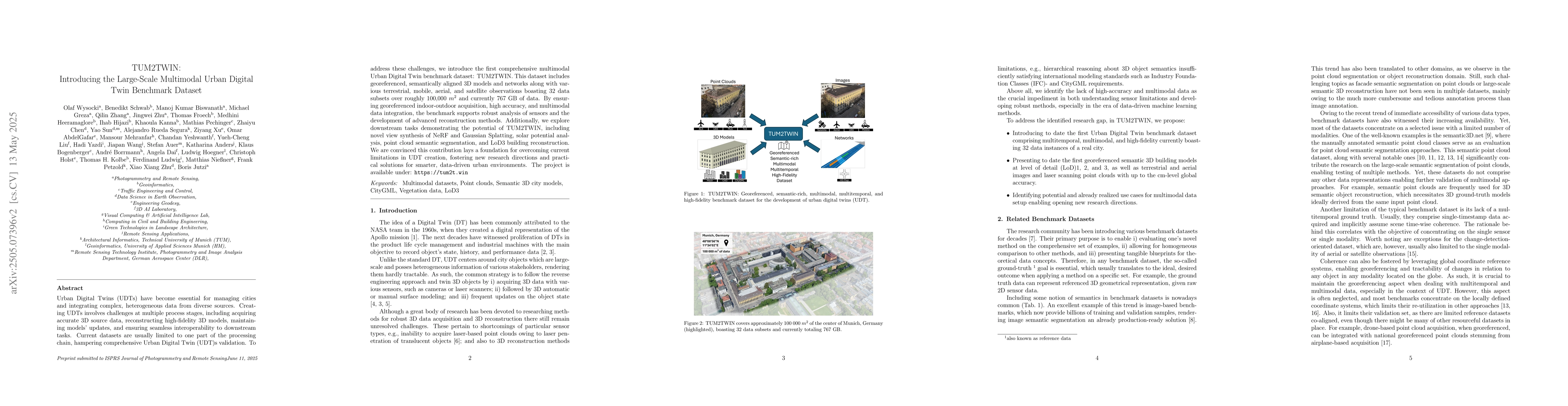
first comprehensive multimodal Urban Digital Twin benchmark dataset: TUM2TWIN. This dataset includes georeferenced, semantically aligned 3D models and networks along with various terrestrial, mobile, aerial, and satellite observations boasting 32 data subsets over roughly 100,000 $m^2$ and currently 767 GB of data. By ensuring georeferenced indoor-outdoor acquisition, high accuracy, and multimodal data integration, the benchmark supports robust analysis of sensors and the development of advanced reconstruction methods. Additionally, we explore downstream tasks demonstrating the potential of TUM2TWIN, including novel view synthesis of NeRF and Gaussian Splatting, solar potential analysis, point cloud semantic segmentation, and LoD3 building reconstruction. We are convinced this contribution lays a foundation for overcoming current limitations in UDT creation, fostering new research directions and practical solutions for smarter, data-driven urban environments. The project is available under: https://tum2t.win

Key Findings, in focus

Seven facets of this paper, analysed and brought into focus by AI.

AI-generated · verify against source Generated Jun 08, 2025
In focus · one-line synthesis

This research lays a foundation for overcoming current limitations in UDT creation, fostering new research directions and practical solutions for smarter, data-driven urban environments.

01
MethodologyHow they did it

The paper introduces TUM2TWIN, a comprehensive multimodal Urban Digital Twin benchmark dataset, encompassing georeferenced, semantically aligned 3D models, networks, and diverse observations spanning terrestrial, mobile, aerial, and satellite data across 100,000 $m^2$ with 767 GB of data.

02
ResultsWhat they found
  • TUM2TWIN dataset supports robust analysis of sensors and development of advanced reconstruction methods.
  • Demonstrates potential of TUM2TWIN in downstream tasks including novel view synthesis (NeRF and Gaussian Splatting), solar potential analysis, point cloud semantic segmentation, and LoD3 building reconstruction.
03
SignificanceWhy it matters

This research lays a foundation for overcoming current limitations in UDT creation, fostering new research directions and practical solutions for smarter, data-driven urban environments.

04
Technical ContributionsWhat's new technically

Introduction of TUM2TWIN, a large-scale multimodal Urban Digital Twin benchmark dataset with high accuracy and multimodal data integration.

05
NoveltyWhat sets it apart

TUM2TWIN is the first comprehensive dataset addressing multiple stages of UDT creation, providing a holistic resource for UDT validation and research.

06
LimitationsWhat to be cautious about
  • The dataset currently covers a limited geographical area (100,000 $m^2$).
  • Specific details on dataset acquisition and processing methodologies are not extensively detailed.
07
Future WorkWhere it goes next
  • Expand the dataset to cover larger urban areas for broader applicability.
  • Investigate additional downstream tasks and applications leveraging TUM2TWIN.

Impact

81
References

Paper Details

Paper ID: 2505.07396
Comments: Submitted to the ISPRS Journal of Photogrammetry and Remote Sensing
Categories:
cs.CV cs.LG

How to Cite This Paper

Reference manager: RIS EndNote

Citation Network

Current paper (gray), citations (green), references (blue)

Display is limited for performance on very large graphs.

Current Paper
Citations
References
Click to view


Discussion 0

This website uses cookies to ensure you get the best experience. Learn more